Contemporary Cartographies
The Language & Imagery of Maps
|
Introduction From their earliest origins, maps have been a visual medium converting the physical world into a two-dimensional system of signs and symbols. They are also conceptual — a schema for delineating borders, establishing relationships, and giving shape to the idea of place. Contemporary Cartographies presents the work of a group of artists who use the language and imagery of maps to communicate an array of ideas. Some use fictional narratives and create imaginary cartographies; others approach the map aesthetically or as material in itself. They work in various styles — adapting, manipulating, and inventing geographies, giving them new meanings. The works resonate with history, culture, politics, identity, and memory. Humor too plays an important role in defining these borders.
|
In The Nile, 2010, Wopo Holup charts the flow of this African river from its delta to Lake Victoria, along twelve panels of Denril velum. In a second work Salton Sea, 2012, she alludes to the negative ecological consequences of an attempt to divert the Colorado River — but does so with using a sensuous expanse of gold leaf. In both works the natural features, such as irrigated areas, meadows, and lakes, are distinguished by her choice of representation and materials. Holup’s use of Google Earth satellite maps allows a detailed view of the landscape.
Contemporary mapping systems like the GPS or Google Earth are also sources of reference for Steven Millar. His installation Link, 2013, looks back in time and draws on childhood memories of his home in the Appalachian Mountains. Fragments of his house dialogue with aspects of the natural landscape of the area — a photograph, shingles, a pillow, a rock, and bedsprings welded into the topography — combine constructed elements with found objects.
Sage Dawson focuses on lost and forgotten parks of the Mid- and South West, as if seen from above. Timeline, 2009, begins on the wall and extends out for twelve feet on the floor. Among traditional techniques and materials — hand-made paper, gold leave, acrylic and lithography — the insertion of hair alludes to the popular 19th century custom of preserving mementoes of loved ones, as sentimental memorials.
 |
A shorter time span is addressed by Gail Biederman inher large-scale installation You & Me, Together & Apart, 2012. Biederman plots autobiographical data to document the contact she and her twin sister have had over a ten-year period. Color-coded cords, made from hand-felted merino wool, drape gracefully between London, where her sister lives; New York, where Biederman lives; and points beyond. Memories and experiences of places visited during the summers of 2009 and 2011 are graphically illustrated in Dahlia Elsayed’s August Landscape, 2009,and Sticky Parts, 2011. With a style reminiscent of the comics, text plays as important a role as images do in these drawings. Phrases like “pitstops and fast getaways” or “general chaos” provide keys or hints to connect to the otherwise unrecognizable urban landscape and islands. As personal comments, they add a dimension to those specific times and places in her life.
|
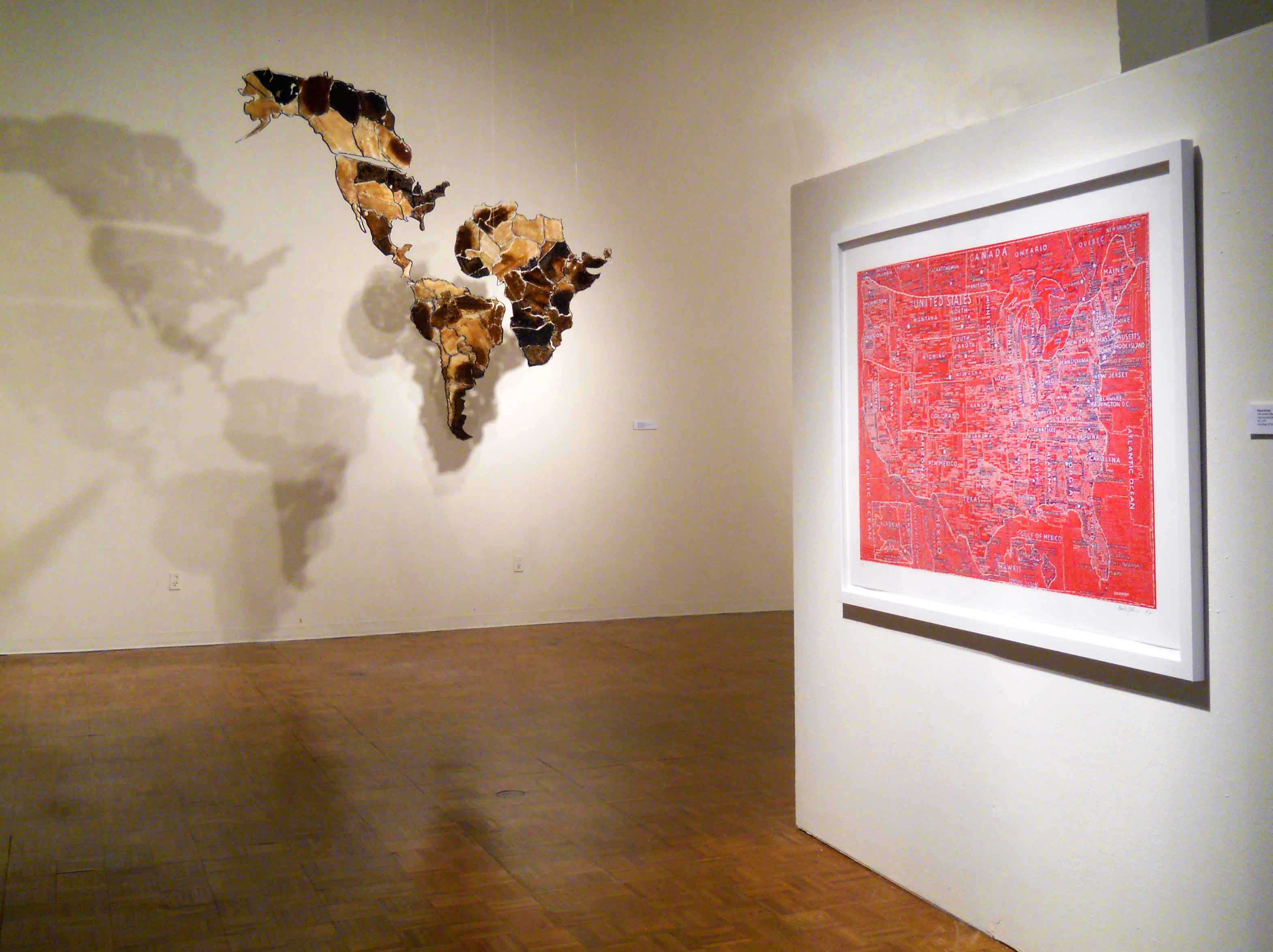
A strong graphic quality is also present in Paula Scher’s hand-pulled silkscreen The United States (Red), 2007. A designer, as well as a painter, Scher depicts the country with its familiar borders filled with calligraphic, handwritten words and numbers, naming cities, rivers, highways, and other features of the map .She collects data from different sources such as newspaper headlines, diagrams, and commercial maps, creating images dense with information.
The map of the United States is a starting point for Karen Shaw. In The United Shapes of America, 2011,she has created collages with the outline of each of the fifty states on separate circles. This colorful work is coded and comes with a legend, indicating the different geographic regions of the country. Arranged alphabetically, it is structured as data, as well as, maps.
|
In Wrangler Map, 2005, Margaret Cusack also creates a map of the country with the machine-stitched pockets of Wrangler Jeans. The United States stands out, full of vibrant colors and textures in the middle of a deep blue denim sea. Cusak’s fiber art map has been used as a promotional piece for the jeans company. Resembling North America at a first glimpse, Lisa Corinne Davis’ Groundless Construct, 2010, is actually a rather abstract painting. Its center core appears to be the gridded neighborhood of a small town that explodes outward into cubist blocks. Cartoon-like organic shapes suggest flora or fauna and add to the mix. Black lines that cover the surface seem to both fragment and connect smaller portions of the territories represented, but the viewer is ultimately left to make his or her own connections.
|
 |
Like Davis, some of the artists make incursions into imaginary and abstract territories, in order to suggest fictional narratives. Dannielle Tegeder’slarge site-specific painting Impossible City: Neighborhoods, Lawnfieillisonia Wakmelongwood, Highbedhavenrose, Trempointwood, and Throgville Island, 2013, recreates structural elements on and behind the wall’s surface, using an invented system of symbols. The painting incorporates the gallery’s vents, light switches, and electrical plugs as a visible part of the mechanical systems. The words of the title humorously recombine the names of Bronx neighborhoods.
The drawings Imaginary Map #1 (Points of Departure), 2006 and Imaginary Map #3, 2006 by Simonetta Moro, on the other hand, are the result of superimposing different aerial views of the city under transparent Mylar. With a great richness of materials and textures, the works mingle real places and facts with personal interpretation and imagination, to the point of abstraction.
 |
The use of map as material, and its potential to add meaning, has been the choice of artists like Meridith McNeal. In Child’s Dress, 2007, and Tiny Bustle Dress, 2007, the artist explores the Victorian epoch, by recreating period fashions from vintage women’s magazines. A life-size girl’s dress and a tiny dress under a bell jar have been made out of New York City transit maps. The viewer is led to establish a parallel between the situation of women at that moment in history, and today. With a very different approach, Doug Beube |
deconstructs maps, physically cutting and recombining the paper into new territories, changing borders and merging political and geographic identities. Four small collages reintegrate the borders of different countries in Europe, South America, and the Middle East. His richly layered sculptural construction Crater, 2009, delicately creates the illusion of a giant sinkhole in the landscape.
Carpet World & Moon, 2007 by Charley Friedman, is comprised of a globe, six-feet in diameter, and a scaled sphere representing the moon. Like a rug, it has been hand-hooked using synthetic yarn. The sculpture’s colorful and playful geography belies the many problematic issues of the globe.
|
Suspensions, 2005-2009 by Isabel Barbuzza, is part of a larger work of the continents. In this exhibition the Americas, together with Africa, are suspended in the air and cast distorted shadows onto the wall. Their outlines recall Pangaea before these land masses pulled apart. The maps are made of honeycombs from a local beekeeper in Mendoza — her hometown in Argentina. The bees too are another reminder of the fragility of the earth. Kevin Van Aelst uses photography to arrange and combine objects and situations from everyday life, as he makes concise statements on the nature of things. In an interesting play of scale, a bitten apple becomes the World — Apple Globe, 2007 — while a full moon is held in a spoon full of sugar — The Moon, 2010. One Heart Beat, 2008, is the portrait of a girl lying down, as if having fallen asleep after reading. The angle of the photo shows the top of her head, which is parted in a way that resembles an EKG (electrocardiogram), while the title suggests it is the sound of a heartbeat. |
 |
Contemporary Cartographies highlights the diverse ways that artists use the language of maps to express ideas and create new imagery. This exhibition brings together many different media, all exploring mapping as a conceptual structure for presenting information in a visual context.


